Read on to learn more about geotagging and the tools necessary to add it to a photography workflow.
A field for GPS coordinates exists in the EXIF metadata field - a standard format for digital photography. Incredibly, the field is most often left empty - even by most professional photographers. There are a few reasons for this, the first is that right now there seems to be little value attached to the information, and secondly the information doesn't appear automatically when the image is created and it is too much extra work to add the information.
Geotagging - the process of inserting GPS data and coordinates into the metadata fields of digital images - seems to have limited value for most professional photographers. As with most processes that involve full and detailed disclosure, geotagging appears to offer the most benefit to the client or end user.
The advantages to a photographer specific "geotagging unit" over a standard gps unit may include the following:
-lightweight
-long battery life
-relatively affordable


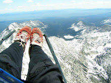
Makes me want to take a trip.
More after the jump...
How cool would it be if someone could come to my web-site, type in the search term "bike" then draw a circle on a map and come up with all my images of bikes that were shot within that circle?
Or better yet, from a photo-editor or photo researcher's standpoint, how convenient would it be for them to do a google search for "horse" then draw a circle on a specific area of Nevada and have all the horse images from the geotagging savy photographers show up on a search?
What if you could right click an image and have an option "reveal shoot location in google maps"? Maybe I'm kidding myself, maybe outside of GE or telling your friends about your last great adventure, knowing exactly where you shot an image will never be commercially useful.
I think it will be valuable one day.
I think it will be valuable one day.
A field for GPS coordinates exists in the EXIF metadata field - a standard format for digital photography. Incredibly, the field is most often left empty - even by most professional photographers. There are a few reasons for this, the first is that right now there seems to be little value attached to the information, and secondly the information doesn't appear automatically when the image is created and it is too much extra work to add the information.
Geotagging - the process of inserting GPS data and coordinates into the metadata fields of digital images - seems to have limited value for most professional photographers. As with most processes that involve full and detailed disclosure, geotagging appears to offer the most benefit to the client or end user.
Standardized and accurate geotagging could preclude a stock photographer from adding a misleading description such as "Man releases trout on the Middle Fork of the Salmon River in Idaho's Frank Church River of no Return Wilderness" to a generic image of a fish and a net with no visual context. By looking at metadata a client might recognize a stock photographer trying to pull one over on them, or a customer or end user might more readilly recognize a corporate add trying to portray themselves as something they are not.
I wonder if standardized geotagging could help create a need for the creation of more original imagery? At the very least geotagging would confirm the claims of an honest stock photographer, and we don't know what technologies have yet to be invented that might exploit this information in ways we can't imagine.
The more immediate reason why the GPS field is often left blank is that geotagging seems like too much extra work. It is logical to assume that someday all our cameras will be gps equipped (the recently released Nikon Coolpix 6000 is the first) and all sorts of data will be written the moment the shutter is released. As of now we are forced to pack around and learn how to use either a traditional gps unit or a photographer specific "geotagging unit," then download and handle the gps data, and finally use third party software to write the coordinates to each image. What a freaking pain. There are already to many steps in most photographers' work flow. Add one more step? Plus, it sounds like something a geeky HP engineer would do after skimming the Craigslist personals on a Saturday morning.
Or Birddog when he is high on narcotics.
In short, geotagging works like this:
1) to the second set your camera's clock to your gps clock
2) turn on and carry gps with tracklog intervals set to 5 seconds or less as you shoot
3) download gps tracklog and photos to computer
4) use 3rd party software that looks at the synched time data to match each image to gps coordinates
While flickr. google, picassa and now even iPhoto '09 offer labor intensive manuel map based solutions there are two approaches that make sense for volume geotagging. The first approach is to use pretty much any normal gps unit to create track logs, then employ third party software to sync up the time stamps, coordinates, and individual images.
The second approach is to buy a photographer specific "geotagging unit," then use included or third party software to sync images and tracklogs.
Either way, it is one more thing the photographer has to pack, travel and shoot with, more batteries to purchase, change and throw away, more software to learn and integrate into a work flow. Oh, boy I can't wait until gps units are included in Canon cameras. In the mean time Adobe engineers should include an "integrate .gpx tracklog on import" option in the import dialogue box of the next Adobe PhotoShop Lightroom update.
As of now, we got what we got.
The advantages to a photographer specific "geotagging unit" over a standard gps unit may include the following:
-lightweight
-long battery life
-relatively affordable
-nothing to learn, a dummy assistant can hit an on/off switch
-remains with camera gear at all times - you'll never forget if you left it in your car, with your flying kit, in your fishing/hunting gear, on your bike, who you lent it to,
-anything else?
Here are a few photographer specific geotagging units:
Royaltek RBT-2300
Holux M-241
Amod AGL3080
GiSTEQ PhotoTrackr CD111
JOBO photoGPS
Qstarz BT-Q1000X
Eye-Fi Pro - this is a cf card that detects local wi-fi connections to automativally geocode your images as you shoot! Super cool if you only take photos at starbucks, the mall, or the airport. Gag me now.
Until I decide which unit to go with I will make do with the Garmin GPSmap 76s gps unit that I fly with and third party software of which there are many options:
GeoSetter seems to be the most talked about on forums, but it is a windows-based program so that doesn't work for me.
In true Google form Google offers a free open sourced version called gpicsync which I overlooked before, but will try.
$30 HoudahGeo
I downloaded and tried out two pieces of software today. Jeffrey’s “GPS-Support” Geoencoding Plugin for Lightroom promised to integrate into my regular LR workflow. It was easy to use, install and it included some cool info like speed and bearing (which, come to think of it is useless unles you were to duct tape your GPS unit to your camera).
Unfortunately, the Geoencoding Plugin writes metadata as a shadow, and the data appears a made up data field - not the EXIF GPS data field. I exported a test with Jeffrey's "include shadow on export" option turned on but the GPS data was useless outside of Lightroom. So much for seamless workflow integration.
I'll give the Google software a go the next chance I get, but I might just use gpsphotolinker with a modified work flow for a while.
New workflow:
1) drag 'n drop/copy image files from card reader to folder on desktop
2) connect GPS to computer
3) import image files/folder into gpsphotolinker
4) use gpsphotolinker to access GPS and sync tracklog to images
5) import images to LR as normal
1) drag 'n drop/copy image files from card reader to folder on desktop
2) connect GPS to computer
3) import image files/folder into gpsphotolinker
4) use gpsphotolinker to access GPS and sync tracklog to images
5) import images to LR as normal

A screen capture of the GPSphotolinker interface
What I like about gpsphotolinker so far is that I don't have to download track logs separately - it can extract track logs from my gps, and it writes GPS and elevation data to the EXIF field as well as city, state, and country information to the IPTC fields. I exported a test file and the coordinates and elevation data were included in the exported file. Sweet.

In LR I can click on the GPS metadata field and a google maps page opens with the location marked on the map.
Makes me want to take a trip.