Day 2:
So the spots arrived in time for the second day, but they still did not have the live tracking feature functioning. Bummer, sorry gang. Maybe you have picked one of the other pilots to follow. Sorry gang.
I launched dead last today because I was taking photos at launch. Bad mistake as far as the flying goes. The advantage to launching early is that you can get up with the best pilots, then watch the lines they take, and get a feel where the up air is and where the the sink resides.
By the time I got off the ground all the good pilots had busted out of the valley and I was left to grovel around on my own. I had a good boost to a low cloud base and stepped on the speed bar to try and make the jump out of the valley. I scratched in crummy lift for a while, then sank out and watched the fiery 112 lb. 5 foot nothing French-Canadian babe boost up and kick my butt out of the Valley. Good work Megs. My track log.
Loading up the vans to head up to launch:


 We had fog, low clouds and discouraging conditions on launch. Eventually the fog and base lifted, and the skies cleared enough to start a task. 40 pilots ended up in goal after a 50 + kilometer task.
 Some of the pilots put in some labor removing branches and roots on launch as we waited for the skies to clear.
 The land owner showed us how to use a shovel, and told us his stories of his days in the hi Sierras:
 Meredyth on launch:
 Nate Scales:
 Andy McReae:
 Bill Hughes and Kieth:
 Ajay:
Ajay: Megs and others:
 Connie checking in pilots:
 I went up in the evening and had an amazing glass-off with Jon, Natalia, and Martin:


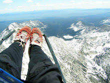
 Life is Grand!
More after the jump...
Life is Grand!
More after the jump...


 pre flight game faces